repoman
Contributor
http://robertscribbler.com/2016/02/29/carbon-monoxide-spikes-to-34000-parts-per-billion-over-california-on-february-26-what-the-heck-is-going-on/
First, there might not be a spike, but a glitch in the data or instruments. Just wanted to get that out of the way.
Seems like an interesting hypothesis:
If there is a massive quake, then this type of spike will be monitored closely.
Wait and see, I guess.
First, there might not be a spike, but a glitch in the data or instruments. Just wanted to get that out of the way.
Considering that all the wildfire and human potential sources for the CO pulse are unlikely to produce the spike in the Nullschool data, that we have no warning of potential impending geological activity from the major agencies, and that we have had no other reports from related agencies to confirm the spike, we should also consider that there may well be something wrong with the monitor. Artifacts can appear in the satellite sensors and it’s not unheard of to get a spike reading due to other signals impacting the sensor.
Seems like an interesting hypothesis:
The Earthquake Precursor Hypothesis
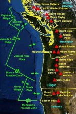
A final suspect for this preliminary observation (which has gotten much hype in social media circles over recent days) is geological. As the apparent spike in the monitor occurs over large fault lines, volcanoes, and above other active geological features along the US and Canadian West, it appears that activity within these features might have produced a brief if intense burp of this gas. Sulfur dioxide (SO2) readings — another geological gas — were also elevated in the monitor, with peak readings again appearing in Southwestern California.
It’s worth noting that no major US or Canadian geological organization has yet made any report on this particularly large CO spike. However, a piece of scientific research in Nature Asia, by K. S. Jayaraman notes that major CO and SO2 spikes may be an indication that future earthquake activity is on the way. According to Nature this kind of intense CO spike occurred prior to a 7.6 magnitude earthquake that shook Gujara in 2001 killing 20,000 people:
Singh said that CO levels were taken by an instrument onboard NASA’s Terra satellite — launched in 2009 — circling the earth in a polar orbit at a height of 705 km. The instrument measures CO concentrations at different heights and also computes the total amount of the gas in a vertical column of air above the earth surface.
Analysis of the satellite data showed a large peak in CO concentrations during January 19 and 20 — a week before the main earthquake event. On January 19, the total CO in the vertical column was also higher than usual. After the 26 January earthquake the concentration of the gas dropped.
According to the scientists, CO gas is forced out of the earth due to the build up of stress prior to the earthquake “influencing the hydrological regime around the epicentre.”
But before we tilt too far into alarmism on this particular possibility, we should consider the fact that the above paper appears to have had no confirmation or further comment in the sciences at this time. So the predictive usefulness of large CO spikes prior to earthquakes remains quite uncertain. And, as noted above, no major geological information outlet has made any warning or comment on earthquake risk so far. Thus the apparent, current very large West Coast CO spike near major fault lines (and over regions suffering from what is now a very severe five-year drought) in this particular monitor remains a bit of a mystery.
If there is a massive quake, then this type of spike will be monitored closely.
Wait and see, I guess.

