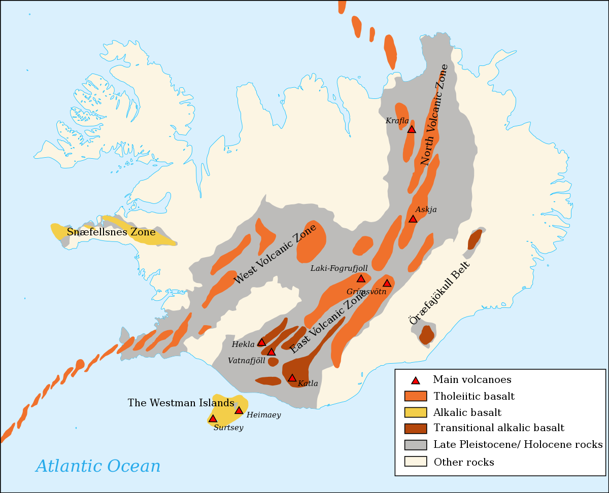
Laki/Skaftáreldar 1783-84
The most deadly volcanic eruption of Iceland's history was the so-called Skaftáreldar (fires of Skaftá) in 1783. The eruption was in the crater row Lakagígar (craters of Laki) southwest of Vatnajökull glacier. The craters are a part of a larger volcanic system with the subglacial Grímsvötn as a central volcano. Roughly a quarter of the Icelandic population died because of the eruption. Most died not because of the lava flow or other direct effects of the eruption but from indirect effects, including changes in climate and illnesses in livestock in the following years caused by the ash and poisonous gases from the eruption. The eruption is thought to have erupted the largest quantity of lava from a single eruption in historic times.[citation needed]
Eldfell 1973
Eldfell is a volcanic cone on the east side of Heimaey which formed during an eruption in January 1973.[7] The eruption happened without warning, causing the island's population of about 5,300 people to evacuate on fishing boats within a few hours. Importantly, the progress of lava into the harbour was slowed by manual spraying of seawater. One person died, and the eruption resulted in the destruction of homes and property on the island.[citation needed]
Eyjafjallajökull 2010
Main article: 2010 eruptions of Eyjafjallajökull
The eruption under Eyjafjallajökull in April 2010 caused extreme disruption to air travel across western and northern Europe over a period of six days in April 2010. About 20 countries closed their airspace to commercial jet traffic and it affected approximately 10 million travellers.[8]
The eruption had a VEI of 4, the largest known from Eyjafjallajökull.[9] Several previous eruptions of Eyjafjallajökull have been followed soon afterwards by eruptions of the larger volcano Katla, but after the 2010 eruption, no activity occurred at Katla.[10]
Grímsvötn 2011
Main article: 2011 eruption of Grímsvötn
The eruption in May 2011 at Grímsvötn under the Vatnajökull glacier sent thousands of tonnes of ash into the sky in a few days, raising concerns of a repeat of the travel chaos seen across northern Europe.[citation needed]
The craters of Grábrók
Hóluhraun 2014–2015
Main article: 2014–2015 eruption of Bárðarbunga
Bárðarbunga is a stratovolcano and is roughly 2,000 metres (roughly 6,560 feet) above sea level in central Iceland, i.e. in the norhern edge of Vatnajökull.[11] This makes it the second highest mountain in Iceland.
Hóluhraun is an older lavafield situated 50 km NE of Bárðarbunga, 20 km S of the Volkano Askja (last eruption 1961), the altitude ca 700 m.a.s. Here the eruption started on August 17, 2014 and lasted for 180 days,[12] The 2014-2015 eruption was Iceland's largest in 230 years.[13] Following a major earthquake swarm, multiple lava fountain eruptions began in Holuhraun.[14] The lava flow rate was between 250 and 350 cubic metres per second and came from a dyke over 40 km long.[15][16] An ice-filled subsidence bowl over 100 square kilometres in area and up to 65 metres deep formed as well.[17] There was very limited ash output from this eruption. The primary concern with this eruption was the large plumes of sulphur dioxide (SO2) in the atmosphere which adversely affected breathing conditions across Iceland, depending on wind direction. The volcanic cloud was also transported toward Western Europe in September 2014.[18]
2021 Fagradalsfjall volcanic eruption
Fagradalsfjall 2021
Following a three-week period of increased seismic activity, an eruption fissure developed near Fagradalsfjall,[19] a mountain on the Reykjanes Peninsula. Lava flow from a 200-meter fissure was first discovered by an Icelandic Coast Guard helicopter on March 19, 2021 in the Geldingadalur area near Grindavík, and within hours the fissure had grown to 500 meters in length.[20]
Litli-Hrútur 2023
On 10 July 2023 at 16:40 UTC, a fissure eruption began adjacent to the summit of Litli-Hrútur.[21]