• Welcome to the new Internet Infidels Discussion Board, formerly Talk Freethought.

Navigation in space

I'd imagine that it'd suck to be at some point in between when that happens.
If the fold is done right there are no points in between.
I can't see how that is possible. Firstly, we aren't talking about points in space but regions of space, and any displacement of a portion of space has to cross other space. Someone can drop an anvil on me if I'm incorrect.

It does make me think about a Kilgore Trout-esque sci-fi where a person invents a time machine that works! But he goes back in time, and Earth (well really the entire solar system / galaxy) is elsewhere, and they die from exposure to a vacuum.

I read a (fictional) story where a time machine was invented that can pass information backwards in time. During the "unveiling" of the device, and discussion of what information they should send back in time, it spontaneously came alive and started spitting out data.... the data read, "SHUT IT OFF!" over and over.
gave me chills.
 
The problem is not just knowing where it will be but matching its motion in space when you get there. You can't just fly by, unless you are tagging the system with something small, like spores; you have to actually stop there.

To that end, you will always have to approach on a curved trajectory.

If you lead the target here, you will pass by the target unless you manage to get so close to a body you can use atmospheric or gravitational braking.

And, you have to spend extra delta-v to stay out of the curved path produced by distorted spacetime. It's literally not worth the energy to go straight.

I think you are confusing moving between planets in a system and interstellar travel. The most fuel efficient Earth to Mars trip would be arced because it is an orbital - thrust is applied at the start which puts the ship into a stretched elliptical orbit about the Sun which will intercept the orbit of Mars. This transfer orbit is a 'straight line' through curved space. Thrust is only applied to start the trip and again to stop by applying thrust to match the orbit of Mars.

The most fuel efficient interstellar trip would also be by only using thrust to start then thrust to stop. Coasting between those two applications of thrust would be along a 'straight line'.

You have to account for relative motion still: it's not enough to be able to intersect the moving target, you have to actually adjust velocity to match the moving target.
No shit? Did you actually read the post you pretend to respond to? If you read for comprehension, you will see that the 'thrust to stop' would be adjusting velocity to match the speed of the 'target'.
And interstellar travel is still orbital. You're just not going to be orbiting the same thing as you were.
WTF???

What, you think that you are traveling free of gravity wells just because you are in a galaxy rather than a mere solar system? Or even between galaxies?

There's always a gravity well and you will always be orbiting it.
 
The old pre GPS LORAN system might work in some form. Multiple transmitters at known locations sending pules in a known order with known timing.

Even if the locations are moving you might still derive relative position.
 
Without any other velocity as a reference frame the logical meaning of "stopped" would be with respect to whatever it was before it was "go".
 
Without any other velocity as a reference frame the logical meaning of "stopped" would be with respect to whatever it was before it was "go".

Indeed.. Velocity or speed are meaningless terms without some reference against which it can be measured. "Stopped" is just a special case of velocity (zero kph) but what it is measured with respect to must be specified to have any meaning.

However for space missions like going to Mars, that "stationary" reference against which velocity is measured has to change sometime during the mission for it to be useful. The thrust needed to reach escape velocity from Earth needs to be with respect to Earth while landing velocity on Mars needs to be with respect to Mars. If velocity were still measured with respect to Earth for the Mars landing then it would be damned fast.
 
The old pre GPS LORAN system might work in some form. Multiple transmitters at known locations sending pules in a known order with known timing.

Even if the locations are moving you might still derive relative position.
The Pioneer mission probes used pulsars (as "LORAN or GPS") to show Earth's location on the plaque.

Sci-Fi stories have suggested that giving away our location may have been a terrible (but trusting) error.
 
Develop capability to bend (fold) time then straight trajectory possible.

If the capability to bend or fold spacetime is achieved then a trajectory isn't necessary. The Navigators in Dune folded spacetime so that where their ship was and where they wanted to go was at the same place... sorta like putting a dot on each end of a sheet of paper then folding the paper so the two dots touched.

I'd imagine that it'd suck to be at some point in between when that happens.

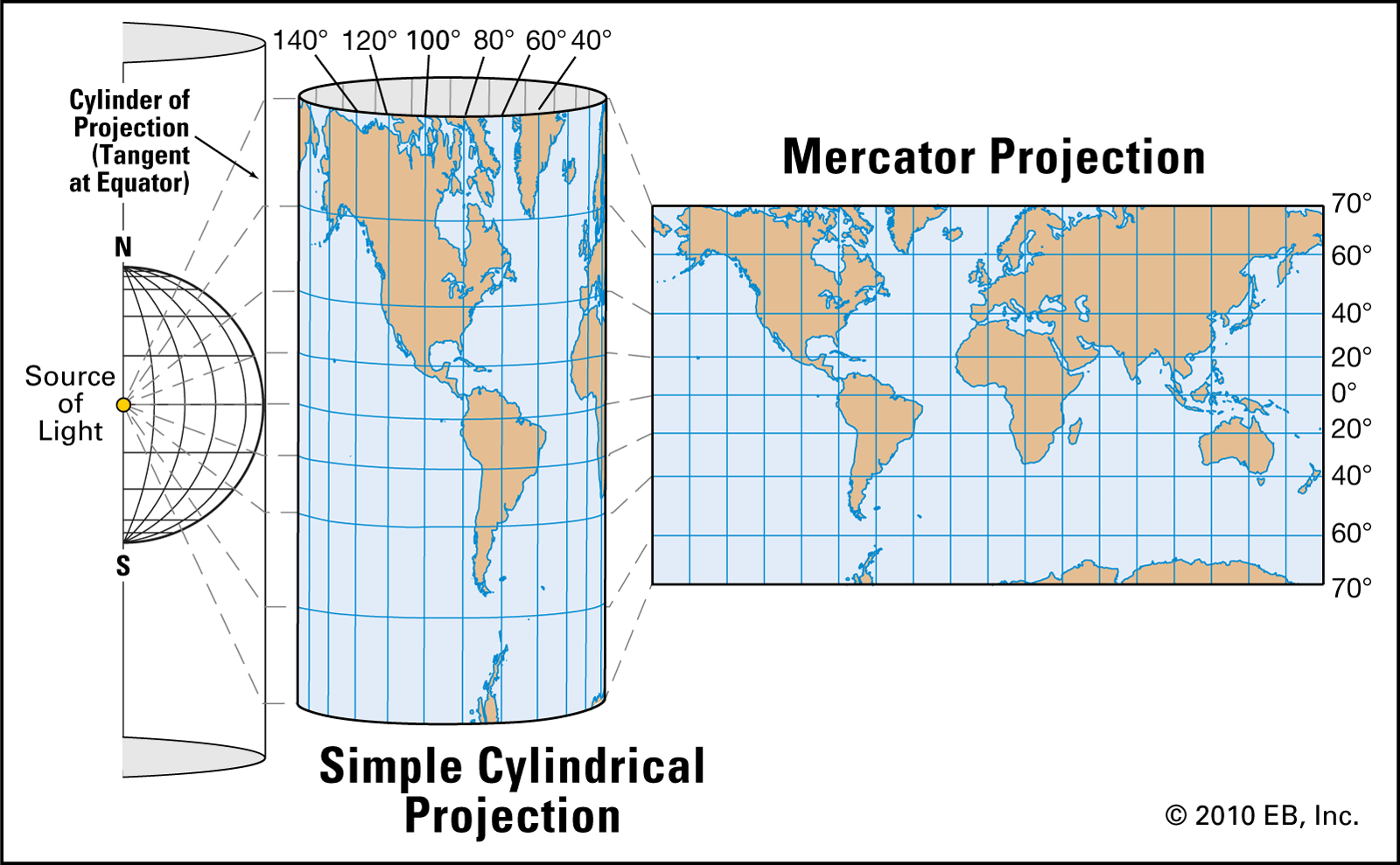
Let's suppose you're on this map somewhere. Colorado or New York or Africa maybe.

Chicago! Perfect, you're in Chicago. The world looks like this:

Picture4.jpg

But now somebody in Alaska wants to fold space so that she can see Russia from her house.

Suddenly the world is sickeningly distorted so that people in
Chicago are ... uh ...

Actually, no, Chicago is unaffected.

transformation-Mercator-navigation-projection.jpg


It does not suck to be between the points folded together.

Unless you don't like being in Chicago. That might suck.
But the sucking would in no way result from the curvature of space that puts Alaska next to Russia.

-- Image from https://www.britannica.com/science/Mercator-projection
 

Attachments

  • pi.jpg
    pi.jpg
    76.6 KB · Views: 1
  • transformation-Mercator-navigation-projection.gif
    transformation-Mercator-navigation-projection.gif
    232.1 KB · Views: 1
The old pre GPS LORAN system might work in some form. Multiple transmitters at known locations sending pules in a known order with known timing.

Even if the locations are moving you might still derive relative position.

We have a pre-existing, galactic system for that. They're called Pulsars.
 
The old pre GPS LORAN system might work in some form. Multiple transmitters at known locations sending pules in a known order with known timing.

Even if the locations are moving you might still derive relative position.
The Pioneer mission probes used pulsars (as "LORAN or GPS") to show Earth's location on the plaque.

Sci-Fi stories have suggested that giving away our location may have been a terrible (but trusting) error.

oop, you beat me to it... and ya, bad idea IMO too.
 
In Trek you always have a reference frame--whatever the primary body is for your location. That could be a planet, that could be a star, it might even be the galaxy as a whole.

Now, being able to accurately measure it is another matter, but this is a mistake that is consistently made in sci-fi stuff--measurements far more accurate than theoretically possible under the conditions.
 
The old pre GPS LORAN system might work in some form. Multiple transmitters at known locations sending pules in a known order with known timing.

Even if the locations are moving you might still derive relative position.
The Pioneer mission probes used pulsars (as "LORAN or GPS") to show Earth's location on the plaque.

Sci-Fi stories have suggested that giving away our location may have been a terrible (but trusting) error.

If evolution is a conat resylting in prey and predator, then unyil we get photon torpedos and warp drive the last thing we want is let oters know we are here.

Watch the Twilight Zone episode Tp Serve Man. It was about an ET book that turned out to be a cookbook.
 
If evolution is a conat resylting in prey and predator, then unyil we get photon torpedos and warp drive the last thing we want is let oters know we are here.
That was Stephen Hawking's position too. But I believe he was looking beyond photon torpedoes and warp drive as a defense as those could be seen as primitive toys to a truly advanced race of space farers.

Personally, I don't think we could hide the fact that Earth is teaming with life from an advanced race even several hundred lightyears away... even if we had never used radio, tv, or radars. An analysis of Earth's atmosphere as we passed between them and the Sun would give them plenty of evidence that the Earth was crawling with life.
 
In Trek you always have a reference frame--whatever the primary body is for your location. That could be a planet, that could be a star, it might even be the galaxy as a whole.

The convenient bit is that you can match the velocity of that primary body by turning off your engines.
 
The old pre GPS LORAN system might work in some form. Multiple transmitters at known locations sending pules in a known order with known timing.

Even if the locations are moving you might still derive relative position.

We have a pre-existing, galactic system for that. They're called Pulsars.

Pulsar emission isn’t isotropic though, so you would have to keep a large catalogue that you keep accessing as you move around.

So it would seem to me that the plaque showing Earth’s location relative to pulsars would only work if you’re actually at earth’s location and can see that set of pulsars that are beamed toward you. Like telling someone where you live by describing what you can see outside your window.
If any space critter finds the Pioneer probes within the next several million years then they would already be damned close to Earth. Pioneer is moving away at about 27,000mph. Voyager (a later probe) overtook Pioneer in the late 1990s. Space critters finding Pioneer would already be close enough to tune into our EM emissions to find Earth so wouldn't need to decipher the plaque.
 
I'd imagine that it'd suck to be at some point in between when that happens.

Let's suppose you're on this map somewhere. Colorado or New York or Africa maybe.

Chicago! Perfect, you're in Chicago. The world looks like this:

View attachment 32745

But now somebody in Alaska wants to fold space so that she can see Russia from her house.

Suddenly the world is sickeningly distorted so that people in
Chicago are ... uh ...

Actually, no, Chicago is unaffected.

transformation-Mercator-navigation-projection.jpg


It does not suck to be between the points folded together.

Unless you don't like being in Chicago. That might suck.
But the sucking would in no way result from the curvature of space that puts Alaska next to Russia.

-- Image from https://www.britannica.com/science/Mercator-projection
It is quite possible that I'm being thick, but the Mercator projection isn't any more real than the cylindrical projection. How do you take an actual sphere and link Cleveland with Chicago, without impacting Toledo?
 
The old pre GPS LORAN system might work in some form. Multiple transmitters at known locations sending pules in a known order with known timing.

Even if the locations are moving you might still derive relative position.

We have a pre-existing, galactic system for that. They're called Pulsars.

Pulsar emission isn’t isotropic though, so you would have to keep a large catalogue that you keep accessing as you move around.

So it would seem to me that the plaque showing Earth’s location relative to pulsars would only work if you’re actually at earth’s location and can see that set of pulsars that are beamed toward you. Like telling someone where you live by describing what you can see outside your window.

Such an accurately conveyed description is adequate to determine position. It's just basic Trigonometry. If I tell you that there are three objects at a precise bearing from my location, and you can identify those three objects (for pulsars, by their distinct frequency), then it is simple math to determine where that point is in space (At that moment in time).
Position and possible velocity within what level of accuracy though? We "know" a pulsar is 152.1 light-years away. That isn't an accurate enough measurement for basing velocity and position in units of what we'd measure motion in as our velocity and positions would be very very well within the precision of the distances to pulsars.
 
It is quite possible that I'm being thick, but the Mercator projection isn't any more real than the cylindrical projection. How do you take an actual sphere and link Cleveland with Chicago, without impacting Toledo?
The Mercator to cylindrical illustration was a 2D analogy of warping our 4D universe. It shows how a 2D universe could be warped through a third dimension to make two distant points overlay. Our 4D spacetime would have to be warped through a 5th dimension to do the same thing.
 
Back
Top Bottom