• Welcome to the new Internet Infidels Discussion Board, formerly Talk Freethought.

Tsunami

I looked on Google earth and now think the size of that cloud is on the order of 600 miles in diameter. This is insane! If it were Yellowstone it would stretch to Boise, Salt lake, to South Dakota, to Canada.
I looked more carefully at the video evidence and found the island that has erupted. The clouds is actually only 85 miles in radius, or 190 miles diameter. Still fucking large.
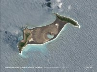
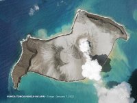
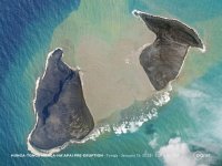
The island that has erupted is now two islands (again)

IMG_6620.JPG
November last year, when the current burst of activity started

IMG_6621.JPG
January 7, just before the big bang

IMG_6622.JPG
January 15, when the smoke and dust cleared enough for the satellite to see the result.
 
The inhabited area is tiny.


Tonga (/ˈtɒŋ(ɡ)ə/ (audio speaker iconlisten), Tongan: [ˈtoŋa][8]), officially named the Kingdom of Tonga (Tongan: Puleʻanga Fakatuʻi ʻo Tonga), is a Polynesian country and also an archipelago consisting of 169 islands, of which 36 are inhabited.[1] The total surface area of the archipelago is about 750 km2 (290 sq mi) scattered over 700,000 km2 (270,000 sq mi) of the southern Pacific Ocean. As of 2021, Tonga has a population of 104,494,[9][10][11] 70% of whom reside on the main island, Tongatapu. The country stretches approximately 800 km (500 mi) north–south. It is surrounded by Fiji and Wallis and Futuna (France) to the northwest; Samoa to the northeast; New Caledonia (France) and Vanuatu to the west; Niue (the nearest foreign territory) to the east; and Kermadec (New Zealand) to the southwest. Tonga is about 1,800 km (1,100 mi) from New Zealand's North Island.
 
In the local news the pressure wave was measured in Seattle going both ways around the globe. It hleped did[ate some fog.

Goes to show how we are interconnected.
 
Before and after satellite pictures show a green island fpllowed by a brown island. covered with ash. Can't be good for flora and fauna.
 
The first RAAF aircraft has landed in Tonga, carrying water, desalination equipment, PPE to protect people from breathing the volcanic ash, and other immediately necessary supplies requested by the Tongan government. A second aircraft is already on its way.

The planes were delayed due to volcanic ash on the runways, which the locals have been clearing by hand, using shovels and wheelbarrows. This work was further hampered by additional ash-falls in the last few days.

HMAS Adelaide, a helicopter carrier designed for the Australian Navy to operate in littoral waters, departed the Port of Brisbane yesterday, with more supplies and personnel. This ship can be used as a floating dock, which may be useful in assisting people on the smaller islands in the Tongan archipelago.
 
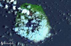
Satellite imagery reveals orange lava incandescence at Tofua, about 100km from Hunga Ha'apai, further along the Tonga Ridge.

Seems that that particular plate boundary is getting pretty volcanically active.

IMG_6632.JPG
 
Yes, I was there over the summer and was shocked at the density of wildlife in the lower basin. In two days, I saw hundreds of bison, a bear family, two moose and a substantial pronghorn herd, along with numerous smaller birds and mammals. I'm not so alarmist as to imagine that this is because of an impending supervolcanic eruption, though; it's a natural consequence of killing or constraining most of the predators in the parklands. It's fine, because functionally Yellowstone is essentially a zoo; repopulating the West with its missing keystone species by growing the surviving herds/lodges is a key part of its charter, along with the public relations aspect that Mother Earth needs to prevent Republicans from voting or murdering her chilldren out of existence. So more animals in front of cameras is a good thing.
 
This video is amazing. The cloud is at least 200 miles in diameter. But is this video in real time? Or speeded up? This looks more like a super volcano!
That is an amazing video. That was one hell of a shock wave to distort the image so much through lensing.
Are you sure it's lensing? I thought so at first too but maybe it's the clouds being shoved aside?
Clouds don't necessarily move with the air mass in which they appear; They aren't typically bounded by a change in composition of the air, but by a change in temperature, pressure, or both. A shockwave can create or destroy cloud, but it can't 'push' it, because it's insubstantial.

IMG_6807.JPG

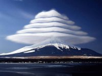
These clouds are stationary relative to the mountain; But the wind speed is quite high, and all of the air, including all of the water droplets and the ice crystals it contains, are moving rapidly past the mountain, and through the 'stationary' clouds.
 
This video is amazing. The cloud is at least 200 miles in diameter. But is this video in real time? Or speeded up? This looks more like a super volcano!
That is an amazing video. That was one hell of a shock wave to distort the image so much through lensing.
Are you sure it's lensing? I thought so at first too but maybe it's the clouds being shoved aside?
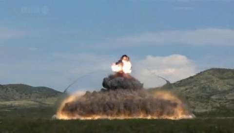
I'm pretty sure. It certainly looks like the view of the background is being distorted through lensing caused by an expanding front of denser air.

Sorta like this:

The big difference being that the shock wave from the volcano covered quite a few miles so the effect could be seen without having to use slow motion video.
 
Last edited:
Back
Top Bottom