• Welcome to the new Internet Infidels Discussion Board, formerly Talk Freethought.

The Earth's three highest mountains - by three definitions

WWI German submarines: test depth 60 m, some survived 90 m

WWII German submarines, Type VII: test depth 230 m, one survived 340 m

Present-day US military submarines: classified, but at least 240 m (800 ft)

So military submarines can't go very far down.
There are subs that have gone all the way to the bottom.
Which ones? How deep?

 Continental shelf - the continental shelves go down to 140 meters, and much of the continental shelves is accessible to most military submarines. The average ocean depth is, however, 3700 m. Is there any military submarine that has survived that depth? Or anything close to that depth?

 List of specifications of submarines of World War II - "Diving Depth"
  • France: 600 series: 25 m, Redoubtable: 35 m
  • Germany: VII: 220 m, IX: 230 m, XXI: 260 m
  • Japan: I-15: 100 m, Kaiten: ?, Kohyoteki: 30 m
  • Netherlands: O21: 115 m
  • UK: T-class: 90 - 105 m, U-class: 90 m
  • US: Gato: 90 - 120 m

Off the top of my head, the Trieste. Research vessels, not combat vessels.
Technically not a submarine, but a bathyscaphe, the difference being that a submarine has a cylindrical pressure hull, while that of a bathyscaphe is spherical, making it considerably more resistant to crushing under high pressure.
 
It's a submarine in the general sense of being a watercraft that can operate underwater. By the way, "U-boat" for German submarines is a partial translation of U-Boot, short for Unterseeboot, "undersea boat".
 
Sounds like Mauna Kea would be the hardest to hike from base to summit.
That's not how it works. Terrain and weather conditions are the biggest factors, not total distance or elevation gain. K2 is not as high as Everest, but is a much more challenging peak, and more people die attempting K2 than Everest.

And he’s out for a duck.
 
Sounds like Mauna Kea would be the hardest to hike from base to summit.
That's not how it works. Terrain and weather conditions are the biggest factors, not total distance or elevation gain. K2 is not as high as Everest, but is a much more challenging peak, and more people die attempting K2 than Everest.
Sure. But think about attempting Mauna Kea from its *base*!
Hiking under 19,000 feet of water can be a real challenge; the ascent to sea level might not be difficult, but the pressure at the bottom is a bitch. In fact the survival rate is zero AFAIK.
I would have thought he survival rate is \(nan\), given that no-one has even tried (for good reasons).
 
Altitude or height (also sometimes known as depth) is a distance measurement, usually in the vertical or "up" direction, between a reference datum and a point or object. The exact definition and reference datum varies according to the context (e.g., aviation, geometry, geographical survey, sport, or atmospheric pressure). Although the term altitude is commonly used to mean the height above sea level of a location, in geography the term elevation is often preferred for this usage.
The elevation of a geographic location is its height above or below a fixed reference point, most commonly a reference geoid, a mathematical model of the Earth's sea level as an equipotential gravitational surface (see Geodetic system, vertical datum). Elevation, or geometric height, is mainly used when referring to points on the Earth's surface, while altitude or geopotential height is used for points above the surface, such as an aircraft in flight or a spacecraft in orbit, and depth is used for points below the surface.

I would think O2 is the major issue with climbing higher peaks. Percentages O2 versus mean seal level.

AGL above ground level. For a pilot MSL mean se level is useless.

If you are making a 3D density map of the Earth then the center of gravity is the reference point.

MSL would be an offset from the center of gravity.

O2 is definitely the limiting factor at high altitude.
There are unrecovered human popsicles on Mt Everest that attest to that.
 
It's also very cold.

I'll be more careful with my temperature estimates, by calculating temperature-adjustment factors in the atmosphere model.

I'll start with the earliest mountain-climbing record, that of Ötzi, named from being found in the Ötztal Alps between Austria and Italy. He was at 3210 m, and he was preserved in a glacier.

References: Bolzano, Italy: 262 m, 11.9 C, -1.4 C -- Innsbruck, Austria: 574 m, 9.4 C, -1.9 C.

 Geopotential height - hg found from geometric height h:
\( \displaystyle{ h_g = \frac{g}{g_0} h } \)
where g0 = 9.80665 m/s^2
Actual gravity from  Gravitational acceleration -  Gravity of Earth

Ötzi - geopotential altitude: 3210 m - temperature correction -1.75 C - avg. temperature -7.6 C


Now Mt. Everest. Geometric height: 8848.86 m - geopotential height 8835.38 m -- only 13.48 m less

References: Kathmandu, Nepal: 1400 m, 18.9 C, +13.0 C -- Lhasa, Tibet, China: 3656 m, 8.8 C, +17.6 C

Using a temperature offset of +15.3 C, I find avg temperature -27.1 C, pressure 0.31 of sea level, density 0.36 of sea level.

You can bundle up against cold pretty well, though. O2 is the limit.

Although this gets me wondering--how do they deal with going to the bathroom? There have been people who lost fingers by short exposure on the summit.
 
Diapers? Those astronaught diapers should be sturdy enough.

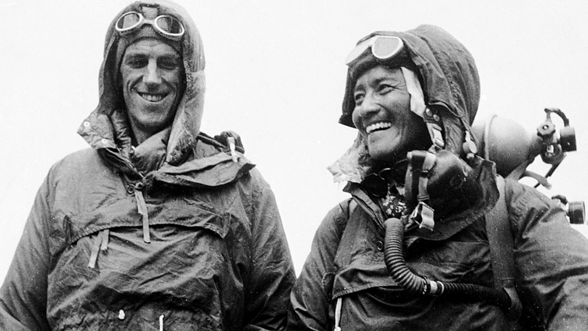
Hilary and Norgay did the Everest first ascent in the 50s with crude equipment and clothes by today's standards. I don't think they used O2.

 
I'd earlier calculated the geopotential height as
\( \displaystyle{ \frac{g}{g_0} h } \)

But that is a first-order approximation, and I must be more careful. The gravitational potential is (-G*M/r) for gravitational constant G, mass M, and distance from the center r. Adding h to r and expanding in a series in h gives us
\( \displaystyle{ \frac{g}{g_0} h - \frac{GM}{r^3} h^2 + \text{higher-order terms, overall O(h**3), nonspherical O(h**2)} } \)

For Ötzi, this additional correction is -1.65 m, and for Everest, -12.29 m, giving 3208 m and 8823.09 m.


By setting 29.92 inHg/1013.4 mb, the altimeter will immediately read pressure altitude. If no altimeter is handy, a simple math formula will provide the same answer. Pressure altitude = { (Sea Level Pressure – 29.92) x 1,000} + true altitude (or field elevation if on the ground) Pressure Altitude Versus Density Altitude


In aviation, pressure altitude is the height above a standard datum plane (SDP), which is a theoretical level where the weight of the atmosphere is 29.921 inches of mercury (1,013.2 mbar; 14.696 psi) as measured by a barometer.[2] It indicates altitude obtained when an altimeter is set to an agreed baseline pressure under certain circumstances in which the aircraft’s altimeter would be unable to give a useful altitude readout. Examples would be landing at a high altitude or near sea level under conditions of exceptionally high air pressure. Old altimeters were typically limited to displaying the altitude when set between {\displaystyle 950~\mathrm {mb} }
{\displaystyle 950~\mathrm {mb} }
and {\displaystyle 1030~\mathrm {mb} }
{\displaystyle 1030~\mathrm {mb} }
. Standard pressure, the baseline used universally, is {\displaystyle 1013.25}
{\displaystyle 1013.25}
hectopascals ({\displaystyle \mathrm {hPa} }
{\displaystyle \mathrm {hPa} }
), which is equivalent to {\displaystyle 1013.25~\mathrm {mb} }
{\displaystyle 1013.25~\mathrm {mb} }
or {\displaystyle 29.92}
{\displaystyle 29.92}
inches of mercury ({\displaystyle \mathrm {inHg} }
{\displaystyle \mathrm {inHg} }
). This setting is equivalent to the atmospheric pressure at mean sea level (MSL) in the ISA. Pressure altitude is primarily used in aircraft-performance calculations and in high-altitude flight (i.e., above the transition altitude).


The density altitude is the altitude relative to standard atmospheric conditions at which the air density would be equal to the indicated air density at the place of observation. In other words, the density altitude is the air density given as a height above mean sea level. The density altitude can also be considered to be the pressure altitude adjusted for a non-standard temperature.

Both an increase in the temperature and a decrease in the atmospheric pressure, and, to a much lesser degree, an increase in the humidity, will cause an increase in the density altitude. In hot and humid conditions, the density altitude at a particular location may be significantly higher than the true altitude.

In aviation, the density altitude is used to assess an aircraft's aerodynamic performance under certain weather conditions. The lift generated by the aircraft's airfoils, and the relation between its indicated airspeed (IAS) and its true airspeed (TAS), are also subject to air-density changes. Furthermore, the power delivered by the aircraft's engine is affected by the density and composition of the atmosphere.
 
Diapers? Those astronaught diapers should be sturdy enough.

Hilary and Norgay did the Everest first ascent in the 50s with crude equipment and clothes by today's standards. I don't think they used O2.

They did. The first recorded ascent without supplemental oxygen was Messner in 1978.
 
Sounds like climbing stairs up a tall building breathing trough a straw with a bag over your head.
 
How Nirmal Purja scaled the world's tallest peaks in record time
“Don’t be afraid to dream big,” Nirmal “Nims” Purja says in the opening voiceover of the new Netflix documentary “14 Peaks: Nothing Is Impossible,” out now. Purja, a 38-year-old mountaineer, didn’t dream big so much as he dreamed tall.

The doc chronicles his attempt to climb all 14 peaks in the world that are over 8,000 meters in seven months. The previous record for such a feat was seven years. Climbing a single eight-thousander is a huge endeavor that can take months, inflict a significant toll on the body and requires a good degree of luck in terms of weather and conditions.

“Anything above 8,000 meters is in ‘the death zone,’ ” filmmaker and fellow mountaineer Jimmy Chin, known for the Oscar-winning climbing documentary “Free Solo,” says in the movie. “You’re breathing about one-third of the amount of oxygen that you would at sea level.”
14 Highest Mountains in the World - Project Base8000
Climbing to the summit of all 14 eight-thousanders is regarded as a mountaineering challenge and as at 2019 only 40 mountaineers have achieved this. The Himalayan Database captures many of these ascents.

...
October 2019 update: Nirmal ‘Nims’ Purja has just broken the world record for summiting these mountains in record time. His ‘Project Possible‘ achieved this Herculean feat in 6 months and 6 days! We were lucky to meet Nims on our trek to Cho Oyu Advance Base Camp.

The Himalayan Database, The Expedition Archives of Elizabeth Hawley

8000ers.com, Statistics, News and Stories about the 14 highest mountains of the world

Everest - The eight-thousanders - shows 3D models of these mountains in webpages
 
 List of mountain ranges

The highest ones are in a strip between the Indian subcontinent and Central Asia. From west to east, Hindu Kush - Pamirs - Karakoram - Himalayas / Transhimalayas - Hangduan. All 14  Eight-thousander peaks are in this strip, including champion Mt. Everest at 8848 m.

They are the result of the Indian plate running into the Eurasian plate.

North of the Himalayas is the Tibetan Plateau, and north of it is the Kunlun Mountains (highest: Liushi Shan, 7167 m). Further north is the Tarim Basin, a low spot, and then the Tian Shan mountains (highest: Jengish Chokusu, 7439 m)

These mountains are part of the  Alpide belt a.k.a the Alpine-Himalayan orogenic belt or the Tethyan orogenic belt. Its western part is the  Alpine orogeny produced by the African and the Arabian plates running into the Eurasian plate.

This is a long strip of mountain ranges that extends along the southern border of the Eurasian plate, extending southern Europe - northern Middle East - southern Central Asia - Southeast Asia - western and southern Malaysia / Indonesia

-

Outside of that long strip, the mountain ranges with the highest mountains are in the  American cordillera a long strip of mountain ranges that extends western North America - Central America - western South America. Its highest peak is Aconcagua in the Andes, at 6962 m. It was produced by the collision of the Pacific plate and some smaller plates on one side, and the Atlantic plate and some smaller plates on the other side.
 
8000 feet is like climbing about 10 Empire Ste Buildings.
 
Sounds like Mauna Kea would be the hardest to hike from base to summit.
That's not how it works. Terrain and weather conditions are the biggest factors, not total distance or elevation gain. K2 is not as high as Everest, but is a much more challenging peak, and more people die attempting K2 than Everest.
Sure. But think about attempting Mauna Kea from its *base*!
Hiking under 19,000 feet of water can be a real challenge; the ascent to sea level might not be difficult, but the pressure at the bottom is a bitch. In fact the survival rate is zero AFAIK.
Oh-ho?

Earth’s tallest mountain is in Hawaii. Here’s what it took to ascend it

 
Back
Top Bottom